What was a tithe?
The tithe was originally one-tenth of the produce of the land which was paid to the church. Tithes became increasingly complex from the late medieval period, as the range of produce began to be defined in wider terms, some payments began to be made in cash rather than goods, either by a modus (fixed sum) or a composition (a sum which could be renegotiated from time to time) and as the impact of the Reformation created lay tithe owners. Yet while the origin of the tithe lay in the medieval period, some land continued to be liable to tithe until 1996.
Many tithes were extinguished when land was enclosed by a Parliamentary Act and award through an allocation of land to the tithe owner(s) in lieu of future tithes, although a few Parliamentary Awards simply commuted them into a cash payment, known as a ‘corn rent’, which fluctuated with the price of grain.
The Tithe Commutation Act of 1836 converted those tithes which were still paid in produce into an annual cash sum, through a rather complex formula. The value of the average annual tithe paid across the whole parish over the previous 7 years was expressed as a monetary sum, known as a rent charge. That sum was then converted to the number of bushels of wheat, barley and oats which could be purchased if one-third of the total rent charge was invested in each. The bushels were then apportioned to each piece of land. Each year the farmer paid the tithe owner the cash sum that would be required to buy that number of bushels of wheat, barley and oats, based on a rolling seven-year average price, advertised in newspapers.
The resultant calculation of the annual payment was modified on a number of occasions. From 1846, annual payments of under £1 could be redeemed on payment of 24 times the annual sum, with these lump sums held centrally in trust for the tithe-owners. In 1891, the landowner became liable for the rent charge rather than the occupier, although in practice landowners collected the payment from their tenants. From 1925, the link to corn prices was broken and a fixed charge introduced, based on the earlier rent charge. The amount due to ecclesiastical tithe-owners was collected centrally and increased slightly to provide a fund that would allow these tithes to be extinguished in 2000. A lower charge was paid directly to lay owners (impropriators), with no fund built up to provide them with any compensation when tithes were extinguished. Under continued pressure from landowners, the system changed again in 1936. The intention was that government stock was given to tithe owners, with tithe payers having to pay to the government an annual annuity over 60 years, to 1996, but the new Act was not implemented across the whole country. All payments were finally abolished by the Finance Act of 1977.

What records were created and what can they tell me about individual farms?
Three main types of tithe record were created as a result of the 1836 Act: maps, apportionments and files. Maps and apportionments only exist for parishes where tithes were still payable on some land in 1836, and many Leicestershire parishes had all their tithes extinguished within a Parliamentary Enclosure Award. Tithe files are more numerous, and may exist even for parishes were all the tithes had been extinguished by 1836, although for some parishes no records survive.
Tithe maps were drawn up between 1836 and the early 1850s, and set out clearly the land within each parish that was liable to tithe and the boundaries of each individual parcel of land within that. They can be on a very large scale, and in many cases they are the earliest map to exist of the parish and its boundaries. More details about tithe maps can be found in the separate research guide to maps before the Ordnance Survey.
An apportionment will have accompanied the map, and its introductory section will often set out the reasons why tithes were not payable on certain lands within the parish. The main part of the apportionment comprises a numbered schedule of the owners and occupiers of every parcel of land where tithes were payable, its area, the land use and the rent charge (in £ or the equivalent in bushels) payable to the tithe owner(s) for that land. This may be accompanied by a revised schedule with details of later amendments to the original apportionment. This is best illustrated by way of example, below.
Tithe files are perhaps the least well known of the records. They are likely to have been pruned over the years, but a tithe file can contain additional information about the process of commutation following the 1836 Act, including minutes of meetings, evidence of witnesses, claims and disputes relating to apportionments, descriptions of local farming conditions and yields, voluntary agreements made and draft copies of the awards imposed by the commissioners in cases where agreement proved impossible to reach. Leicestershire has been identified by Roger Kain and Richard Oliver as the county with the greatest proportion of tithe districts (78%) where landowners and tithe owners could not reach agreement on commutation voluntarily. Files can exist even when the tithes had been fully extinguished before 1836, and may set out how and when that had occurred and how the allotments of land were calculated that were given to the rector (and vicar where appropriate) in lieu of future tithes. This may provide information that does not appear within the enclosure award.
Where can I find these records?
Three copies of the tithe map and list of apportionments may survive. One copy would usually have been provided to the parish for future reference and a second copy may have been provided to the diocese (where the tithe owner was the church). If these copies survive for Leicestershire parishes they have usually found their way to the Record Office for Leicestershire, Leicester and Rutland (which has a separate card index for tithe maps). A further copy of each was kept by the tithe commissioners and will now be at The National Archives at Kew, where they may only be viewed on microfilm. The tithe files can only be seen at The National Archives and will be listed in their catalogue. As tithe files with no contents can exist, before making a journey to Kew it is worth looking at two alternative and very useful finding aids, which give details of the content of the tithe files and the level of information shown on the tithe maps:
R.J.P Kain, R.E.J Fry and H.M.E. Holt, An Atlas and Index of the Tithe Files of Mid-nineteenth-century England and Wales (Cambridge University Press, Cambridge, 1986). The index, arranged by county, includes on a parish by parish basis the National Archives catalogue number for every tithe file, whether any tithes were still payable in 1836 and a summary of any documents contained within the file (for example, minutes, report, voluntary agreement, compulsory award).
R.J.P Kain and R.R. Oliver, The Tithe Maps of England and Wales (Cambridge, Cambridge University Press, 1995) includes the National Archives catalogue numbers for tithe maps (and by default for the tithe apportionments). Arranged by county and parish, it includes the date of the apportionment, the number of acres it covered, the date of the map and its scale, and brief details of the features shown. These labelled features can be relevant to many other aspects of local history, and include, for example, a brickyard in Billesdon, a toll bar in Belton and a theatre in Ashby de la Zouch.
The National Archives has an online research guide to these records which provides more information.
Examples
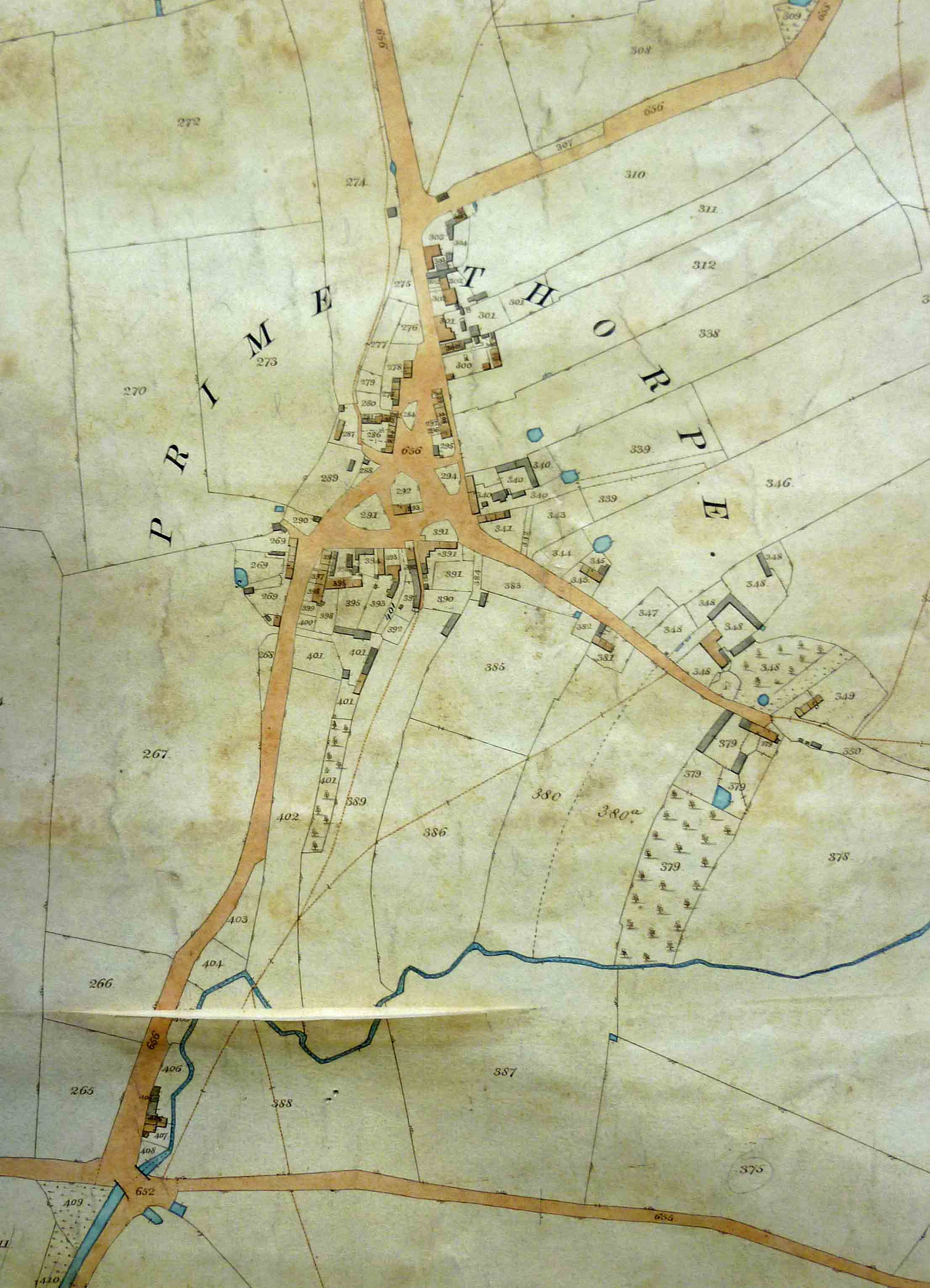
The tithe map for Broughton Astley (copy at The Record Office for Leicestershire, Leicester and Rutland, catalogue reference Ti/51/1a) includes the separate settlements of Primethorpe (now absorbed within Broughton Astley) and Sutton in the Elms. It shows individual buildings, delineating the built area of each settlement in 1845.
The following extract is from the accompanying apportionment:
| Landowner | Occupiers | Numbers referring to the plan | Name and description of lands and premises | State of cultivation | Quantities in statute measures | Amount of rent charge apportioned upon the several lands payable to the rector of Broughton Astley | ||||
| A | R | P | £ | s | d | |||||
| Pegg, James | James Pegg | 266 | Home close | Meadow |
3 |
21 |
5 |
11 |
||
| 338 | Thorpe close | Meadow |
2 |
2 |
33 |
1 |
3 |
0 |
||
| 406 | House, blacksmith’s shop, Peathouse, Outbuilding, Yard and Gardens |
29 |
1 |
0 |
||||||
| 439 | Stathans Close | Arable |
3 |
2 |
30 |
17 |
3 |
|||
| 440 | Far Stathans Close | Arable |
2 |
2 |
5 |
11 |
1 |
|||
| 441 | Bottom Stathans Close | Arable |
2 |
1 |
11 |
10 |
10 |
|||
| TOTAL |
12 |
1 |
9 |
3 |
9 |
1 |
||||
It is apparent from this extract that James Pegg was a blacksmith, but as well as his smithy he had a fairly substantial smallholding comprising 8½ acres of arable land and 3½ acres of meadow near his house, which was well situated for his occupation, on the junction of two roads. It serves as a reminder that not every farmer was wholly dependent on agriculture for his living.
There is no tithe map or apportionment for Groby, as all the tithes were extinguished by a Parliamentary Enclosure Award of 1790, which allotted 131 acres 3 roods and 12 perches of land to the impropriator (lay rector) and 41 acres 2 roods and 26 perches to the vicar in lieu of all future tithes. Yet there is a tithe file at The National Archives (IR 18/4480), which reveals that these allotments were calculated on the basis of 1/7 of the arable land, 1/8 of the meadow and 1/10 of the pasture being enclosed in 1790, plus 1/10 of all the previously enclosed lands and woods, information which is not available in the enclosure documents.
The tithe file for neighbouring Ratby (IR 18/4594) is even more informative, as tithes were still payable on some land, and voluntary agreement on how they should be commuted could not be reached. One of the most useful part of the file, for a study of farming in the parish, is the detailed schedule of the owners and occupiers of land, in the format shown in the first three lines of this document, reproduced below:
| Owners | Occupiers | Name of farm or field | Quantity | How Cultivated | |||||||
| Arable | Pasture | ||||||||||
| A | R | P | A | R | P | A | R | P | |||
| Earl of Stamford | Richard Sarson | Burrow Farm |
117 |
2 |
25 |
59 |
2 |
25 |
58 |
0 |
0 |
| Earl of Stamford | Earl of Stamford | Burrow Woods |
48 |
0 |
0 |
||||||
| Earl of Stamford | Richard Sarson | Old Hays |
134 |
0 |
5 |
66 |
1 |
17 |
67 |
2 |
28 |
Further reading
If you want to know more about tithe maps, apportionments and files, the best introduction is:
R.J.P Kain and H.C. Prince, Tithe Surveys for Historians (Phillimore, Chichester, 2000)
Return to Farming in Leicestershire, from 1790